
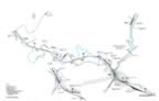
Avella Map In The P&WV Era
| Here is a map of Avella, PA showing MP 81 to 87. This shows the mine locations and the spurs and sidings that serviced them. This map shows area as it was from the 1920s to the late 1950s. |
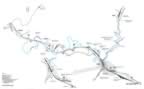
Avella Map In The P&WV Era
| Here is a map of Avella, PA showing MP 81 to 87. This shows the mine locations and the spurs and sidings that serviced them. This map shows area as it was from the 1920s to the late 1950s. |
|
|
|